
The Mediterranean Island Arc
The Mediterranean as a Web
The Mediterranean is often described in political terms, divided into eastern and western theatres or segmented by national boundaries. In practice, however, it functions as a web, where the movement of goods, people, energy and information follows routes shaped less by borders than by distance, depth, weather, and access. Events in one part of the sea rarely remain isolated for long.
This connectivity is a product of geography. The Mediterranean is enclosed, narrow in places and densely populated along its shores. Major ports, energy terminals and transport corridors sit close to one another, linked by short sea lanes and frequent crossings. Unlike open oceans, where distance absorbs shock, the Mediterranean tends to transmit it. Disruption, congestion or instability in one area often ripples outward and affects movement elsewhere.
Islands play a central role in holding this system together. Scattered across the basin, they break long distances into manageable segments and anchor routes that would otherwise be exposed. Historically they have served as waypoints for trade and travel, and today they continue to structure maritime and air movement in much the same way.
Seen in this way, the Mediterranean is less a frontier than a shared operating space in which commercial shipping, ferry traffic, energy flows and surveillance all overlap. Civilian and security functions coexist and frequently rely on the same infrastructure and routes. The distinction between peacetime normality and heightened stress is therefore thinner than it might first appear.
Understanding the Mediterranean as a connected web provides a necessary starting point. It shifts attention away from individual coastlines and towards the relationships between them, and it clarifies why islands, particularly when viewed collectively rather than individually, carry significance that exceeds their size.
The Island Arc in Practice
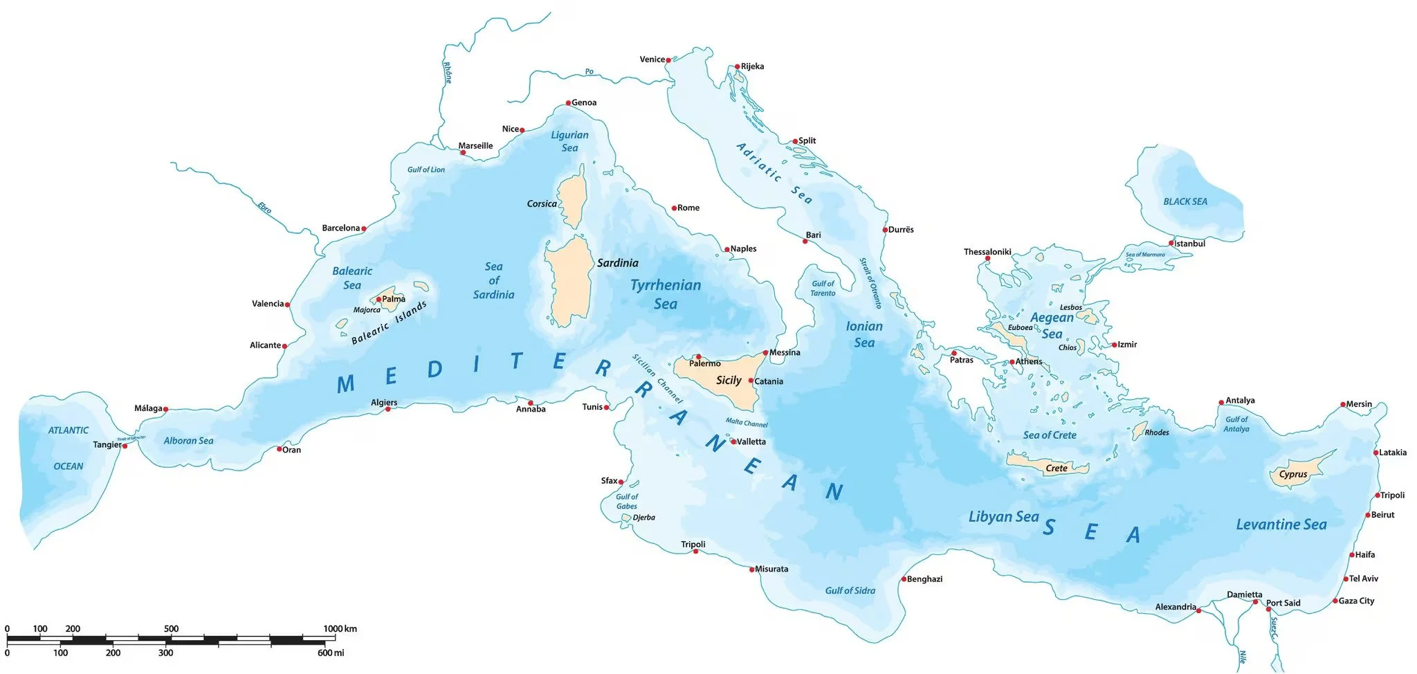
Across the Mediterranean, a loose arc of islands links the western basin to the Levant. These islands differ sharply in size, population and political context, yet together they structure how movement across the sea actually works: they anchor routes, shorten distances and provide points of access that turn the Mediterranean from open water into a navigable system.
At the western end of this arc, the Balearic Islands sit astride routes connecting the Iberian Peninsula to southern France and Italy. Their role is shaped less by the scale of deployed forces than by infrastructure, connectivity and proximity to major shipping lanes. They act as a western anchor that stabilises traffic entering and leaving the central seas and ties the western Mediterranean into the broader system.
Moving eastwards, Corsica and Sardinia occupy a central position between continental Europe and North Africa. Their size allows a depth of infrastructure and transport that smaller islands cannot provide, and they sit at a crossroads of maritime and air routes.
Further south, islands such as Pantelleria and Lampedusa illustrate a different function. They are not mega-hubs but points of proximity. Their position places them close to key transit corridors and areas of persistent movement, from commercial traffic to migration and search-and-rescue activity. Their strategic relevance derives from location and access, even where permanent presence and capacity are limited.
At the eastern end of the arc, Crete and Cyprus serve as hinges rather than endpoints. They connect the central Mediterranean to the Aegean and the Levant, extending the system eastwards while remaining integrated within it. Their scale, infrastructure and connectivity allow them to support sustained activity across multiple domains.
Considered together, this arc does not form a continuous line of defence or a uniform network of bases. It functions instead as a chain of uneven but complementary nodes: some islands provide capacity, others proximity and others access. Its significance lies not in symmetry but in the way these differing roles overlap to sustain movement across the basin. From this perspective, the Mediterranean island arc appears as a structure that exists regardless of formal recognition and continues to shape how the sea is used, managed and stabilised in practice.
Uneven Presence Along the Chain
Viewed individually, the islands that make up the Mediterranean arc can appear mismatched. Some host significant infrastructure and permanent capacity, while others support only a light or intermittent presence. From a distance, this unevenness is often interpreted as weakness or neglect.
Permanent concentration is neither necessary nor desirable across the entire arc. Islands differ in size, connectivity, political sensitivity, and proximity to major population centres. Heavy basing in every location would impose costs that outweigh its benefits, increasing vulnerability while straining logistics and governance. Instead, presence tends to follow function. Larger, better-connected islands attract more enduring capacity, while those valued mainly for their proximity or access usually carry a lighter, more flexible footprint.
Islands with limited permanent presence retain value as surge locations, access points or monitoring nodes without carrying the burden of constant sustainment. Their relevance lies in availability rather than in continuous occupation, and the ability to scale activity up or down matters more than maintaining uniform visibility across the map.
Uneven presence also reflects the overlapping civilian and security roles that islands play. Ports, airfields and transport links serve daily economic and social needs long before they support heightened activity. Maintaining these systems for routine use often does more to preserve stability than formal expansion of military infrastructure. In this sense, restraint is not absence but a choice shaped by geography, cost and continuity.
Considered as a whole, the island arc functions because its nodes are different, not because they are equal. Capacity, access and proximity are distributed unevenly, but they overlap enough to sustain movement and response across the basin. What appears fragmented at the local level coheres at the system level, producing a network that relies on variation to remain adaptable and resilient.
Friction Along the Chain
The Mediterranean island arc functions because movement across it is possible, but that movement is rarely smooth. Distances may be short, yet friction accumulates quickly. Infrastructure quality varies widely, as do maintenance standards and administrative capabilities. What appears continuous on a map can feel strained when systems are pushed beyond routine use.
Much of this friction is logistical rather than political. Ports that perform well under normal commercial conditions can become bottlenecks when demand shifts. Airfields designed for regional traffic may lack the capacity to support sustained lift or rapid scaling. Inter-island transport is often optimised for seasonal rhythms, leaving little margin when conditions change.
Civilian and security uses overlap across much of the chain. Ferries, ports, fuel storage and air links serve everyday needs long before they support heightened activity. This overlap provides reach, but it also introduces vulnerability. Disruption does not need to be dramatic to matter: delays, congestion or deferred maintenance can reduce flexibility across the sea without ever triggering a clear crisis.
The island arc is therefore not fragile, but neither is it frictionless. Its effectiveness depends on how strain is absorbed and managed over time. Where friction is recognised and worked around, continuity is preserved. Where it is ignored, small stresses accumulate into larger constraints that quietly narrow options across the system.
Why This Matters
The Mediterranean island arc shapes outcomes long before any formal coordination is discussed. Movement, access, and continuity are already organised around these islands, even if no single framework acknowledges them. Their collective role emerges from use rather than design and from habit rather than doctrine. The system works because geography encourages it to work.
Viewed this way, cooperation across the arc is less a political achievement than a practical necessity. Islands anchor routes, support everyday movement and absorb strain simply by being used. Their value lies in keeping the Mediterranean functional as a shared space, not in signalling intent or projecting force.
This perspective also helps explain why the island chain resists simple categorisation. It is neither a defensive line nor a cohesive network, neither fragile nor self-sufficient. It persists because it is adaptable, uneven and constantly in use, and its significance becomes most visible when movement slows, connections weaken or maintenance slips.
Understanding the island arc in these terms does not point towards a programme or a plan. It offers a way of seeing the Mediterranean as it already operates. Islands do not divide the sea; they maintain and organise it.